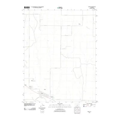
2010 Map of Hugo
USGS Topo · Published 2010About this map
Hugo serves as the focal point of this high-plains landscape, situated along the banks of Big Sandy Creek. The town's layout and surrounding rural infrastructure reflect its role as a regional hub in Lincoln County during the early 21st century. Several burial grounds, including the Hugo Evergreen Cemetery, Mount Calvary Cemetery, and the Hugo Old Cemetery, provide a concentrated footprint for genealogical research within the immediate vicinity of the town.
Find a feature on this map
27 named features on this map. Tap any name to fly to it.
Don’t see what you’re looking for? This feature index may not catch every label — zoom into the map to look around manually.
Map Details
Editions of this 2010 Hugo Map
This is the sole edition of this map. No revisions or reprints were ever made.
Other maps of this area

1891 · Limon
USGS Topo · 1:125,000

1892 · Limon
USGS Topo · 1:125,000

1954 · Limon
USGS Topo · 1:250,000

1957 · Limon
USGS Topo · 1:250,000

1958 · Limon
USGS Topo · 1:250,000

1978 · Clifford
USGS Topo · 1:24,000

1979 · Sevenmile Ranch
USGS Topo · 1:24,000
1979 · Clifford
USGS Topo · 1:24,000

1979 · Arriba
USGS Topo · 1:24,000
1979 · Barron Creek
USGS Topo · 1:24,000