
1979 Map of Arriba
USGS Topo · Published 1979About this map
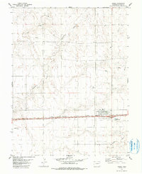
Arriba sits as the central hub of this High Plains landscape, situated along the critical corridor of the Chicago Rock Island and Pacific railroad. The town's grid is clearly defined, featuring a local Park and essential infrastructure like the Sewage Disposal Ponds to the east. Outside the settlement, the geography is shaped by a series of intermittent drainages, including the aptly named Hell Creek, Hackberry Creek, and Buffalo Creek, which carve gentle patterns across the open terrain.
Find a feature on this map
16 named features on this map. Tap any name to fly to it.
Don’t see what you’re looking for? This feature index may not catch every label — zoom into the map to look around manually.
Map Details
Editions of this 1979 Arriba Map
2 editions found
Other maps of this area

1954 · Limon
USGS Topo · 1:250,000

1957 · Limon
USGS Topo · 1:250,000

1958 · Limon
USGS Topo · 1:250,000

1978 · Hugo 4 NW
USGS Topo · 1:24,000

1979 · Arriba NW
USGS Topo · 1:24,000

1979 · Sevenmile Ranch
USGS Topo · 1:24,000

1979 · Flagler SW
USGS Topo · 1:24,000

1979 · Genoa East
USGS Topo · 1:24,000

1979 · Flagler NW
USGS Topo · 1:24,000
1979 · Hugo 4 NW
USGS Topo · 1:24,000