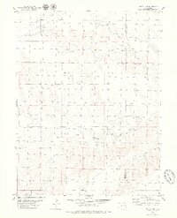
1979 Map of Hugo 4 NW
USGS Topo · Published 1979About this map
South Fork Republican River carves a winding path through this corner of the High Plains, illustrating the hydrological network of Eastern Colorado in the late 1970s. The landscape is characterized by intermittent drainage patterns and significant elevation shifts, typical of the arid prairie regions where water sources like Duck Creek and scattered Springs dictated the utility of the land. Infrastructure is sparse but telling, with Storage Bins and a Tank appearing as lonely markers of human presence in a vast pastoral expanse. These features, along with a prominent pipeline, reflect the region's focus on resource management and agriculture along the boundary of Lincoln and Kit Carson counties. The map serves as a record of the rural topography before further modernization, preserving the specific locations of water points and ranching infrastructure.
Find a feature on this map
6 named features on this map. Tap any name to fly to it.
Don’t see what you’re looking for? This feature index may not catch every label — zoom into the map to look around manually.
Map Details
Editions of this 1979 Hugo 4 NW Map
2 editions found
Other maps of this area

1954 · Limon
USGS Topo · 1:250,000

1957 · Limon
USGS Topo · 1:250,000

1958 · Limon
USGS Topo · 1:250,000

1978 · Clifford
USGS Topo · 1:24,000

1978 · Hugo 4 NW
USGS Topo · 1:24,000

1979 · Sevenmile Ranch
USGS Topo · 1:24,000
1979 · Clifford
USGS Topo · 1:24,000

1979 · Hugo 4 NE
USGS Topo · 1:24,000

1979 · Arriba
USGS Topo · 1:24,000

1979 · Flagler SW
USGS Topo · 1:24,000