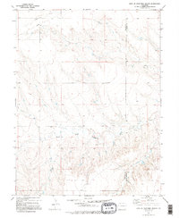
1979 Map of East Of Sevenmile Ranch
USGS Topo · Published 1995About this map
The South Fork Republican River carves a winding path across this section of the High Plains, establishing a landscape defined by drainage patterns and agricultural infrastructure. In the late 1970s, the terrain here remained focused on ranching and dryland resource management, evidenced by the presence of Storage Bins and a Tank situated near the county line. The map highlights the transition across the Lincoln and Kit Carson county boundary, where the headwaters and seasonal flows of Duck Creek and scattered Springs provide the only significant water sources in an otherwise arid expanse. The integration of modern utility is noted by a prominent Pipeline cutting through the northwestern sections, reflecting the era's energy developments across these remote eastern Colorado townships.
Find a feature on this map
7 named features on this map. Tap any name to fly to it.
Don’t see what you’re looking for? This feature index may not catch every label — zoom into the map to look around manually.
Map Details
Editions of this 1979 East Of Sevenmile Ranch Map
2 editions found
Other maps of this area

1954 · Limon
USGS Topo · 1:250,000

1957 · Limon
USGS Topo · 1:250,000

1958 · Limon
USGS Topo · 1:250,000

1978 · Clifford
USGS Topo · 1:24,000

1978 · Hugo 4 NW
USGS Topo · 1:24,000

1979 · Sevenmile Ranch
USGS Topo · 1:24,000
1979 · Clifford
USGS Topo · 1:24,000

1979 · Hugo 4 NE
USGS Topo · 1:24,000

1979 · Arriba
USGS Topo · 1:24,000

1979 · Flagler SW
USGS Topo · 1:24,000