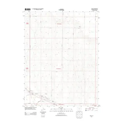
2013 Map of Hugo
USGS Topo · Published 2013About this map
Big Sandy Creek defines the lower drainage of this High Plains landscape, where the town of Hugo serves as a central hub for the surrounding ranching and agricultural lands. The community layout is clearly defined by its street grid, featuring High St and Church St, and is anchored by the Lincoln County Fairgrounds. This 2013 survey provides significant detail for genealogists, documenting the locations of multiple local burial sites including Hugo Evergreen Cem, Mt Calvary Cem, and the Hugo Old Cem. A unique piece of local history is preserved in the location of the Doctor A H Coulson Grave west of the main settlement. Further north, the terrain is marked by intermittent watercourses like Buffalo Cr and Barron Cr, which cut through the open country organized by a network of county roads such as CO Road 109 and CO Road 3E.
Find a feature on this map
38 named features on this map. Tap any name to fly to it.
Don’t see what you’re looking for? This feature index may not catch every label — zoom into the map to look around manually.
Map Details
Editions of this 2013 Hugo Map
This is the sole edition of this map. No revisions or reprints were ever made.
Other maps of this area

1891 · Limon
USGS Topo · 1:125,000

1892 · Limon
USGS Topo · 1:125,000

1954 · Limon
USGS Topo · 1:250,000

1957 · Limon
USGS Topo · 1:250,000

1958 · Limon
USGS Topo · 1:250,000

1978 · Clifford
USGS Topo · 1:24,000

1979 · Sevenmile Ranch
USGS Topo · 1:24,000
1979 · Clifford
USGS Topo · 1:24,000

1979 · Arriba
USGS Topo · 1:24,000
1979 · Barron Creek
USGS Topo · 1:24,000