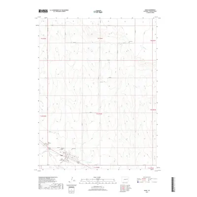
2019 Map of Hugo
USGS Topo · Published 2019About this map
Hugo serves as the focal point of this Eastern Colorado landscape, situated along the intersection of CO Hwy 109 and various numbered streets including 1st St through 7th St. As the county seat, the Lincoln County Courthouse stands as a prominent local landmark. The community's history is deeply etched into the land through several burial sites, ranging from the Hugo Evergreen Cem and Mount Calvary Cem on the western edge to the Hugo Old Cem and the individual Doctor A H Coulson Grave nearby. Beyond the town limits, the terrain is defined by a network of drainage features like Barron Creek, Buffalo Creek, and Willow Spring. Further north, the isolated Parker Cem sits among a grid of section lines and county roads, reflecting the dispersed rural settlement pattern characteristic of the High Plains.
Find a feature on this map
34 named features on this map. Tap any name to fly to it.
Don’t see what you’re looking for? This feature index may not catch every label — zoom into the map to look around manually.
Map Details
Editions of this 2019 Hugo Map
This is the sole edition of this map. No revisions or reprints were ever made.
Other maps of this area

1891 · Limon
USGS Topo · 1:125,000

1892 · Limon
USGS Topo · 1:125,000

1954 · Limon
USGS Topo · 1:250,000

1957 · Limon
USGS Topo · 1:250,000

1958 · Limon
USGS Topo · 1:250,000

1978 · Clifford
USGS Topo · 1:24,000

1979 · Sevenmile Ranch
USGS Topo · 1:24,000
1979 · Clifford
USGS Topo · 1:24,000

1979 · Arriba
USGS Topo · 1:24,000
1979 · Barron Creek
USGS Topo · 1:24,000