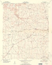
1952 Map of Hulaco
USGS Topo · Published 1952About this map
Cameron Mountain anchors the northwestern corner of this 1952 topographic study, where the Huntsville Meridian and the Old Cherokee Boundary intersect to define the historic survey lines of the region. The landscape is fundamentally shaped by the Tennessee Valley Divide, which separates the northern drainage of Cotaco Creek from the southern headwaters of Warrior Creek. This division is mirrored in the settlement patterns, as local life centers around several rural crossroads and community hubs like Hulaco, Joppa, and Baileyton. Numerous country churches and schools, such as Corinth Church and the Hulaco Sch, are situated along the ridgelines and creek branches, illustrating the mid-century agricultural character of the borderlands between Morgan, Marshall, and Cullman counties.
Find a feature on this map
51 named features on this map. Tap any name to fly to it.
Don’t see what you’re looking for? This feature index may not catch every label — zoom into the map to look around manually.
Map Details
Editions of this 1952 Hulaco Map
2 editions found
Other maps of this area

1885 · Gadsden
USGS Topo · 1:125,000

1888 · Cullman
USGS Topo · 1:125,000

1888 · Gadsden
USGS Topo · 1:125,000

1892 · Cullman
USGS Topo · 1:125,000

1892 · Gadsden
USGS Topo · 1:125,000

1895 · Gadsden
USGS Topo · 1:125,000

1903 · Gadsden
USGS Topo · 1:125,000

1936 · Guntersville Dam
USGS Topo · 1:24,000

1936 · Hulaco
USGS Topo · 1:24,000

1936 · Arab
USGS Topo · 1:24,000