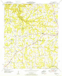
1952 Map of Hulaco
USGS Topo · Published 1952About this map
The Tennessee Valley Divide crests across this landscape, marking the geographic split between northern drainage and the southward flow of the Warrior Creek. This mid-century survey captures a rural Alabama community at the intersection of several county lines, including Morgan, Marshall, Cullman, and Blount. The settlement pattern is defined by upland crossroads such as Ryan Crossroads and Winn Crossroads, and small population centers like Hulaco and Joppa. A dense network of community infrastructure is visible, including the Hulaco School and numerous country houses of worship like Hebron Church and Corinth Church. The presence of the Huntsville Meridian provides a precise surveying baseline that dictated the local land grid, while the terrain shifts from the prominent Cameron Mountain down into Hog Jaw Valley, reflecting a traditional agricultural economy established before significant suburban expansion from nearby towns.
Find a feature on this map
52 named features on this map. Tap any name to fly to it.
Don’t see what you’re looking for? This feature index may not catch every label — zoom into the map to look around manually.
Map Details
Editions of this 1952 Hulaco Map
2 editions found
Other maps of this area

1885 · Gadsden
USGS Topo · 1:125,000

1888 · Cullman
USGS Topo · 1:125,000

1888 · Gadsden
USGS Topo · 1:125,000

1892 · Cullman
USGS Topo · 1:125,000

1892 · Gadsden
USGS Topo · 1:125,000

1895 · Gadsden
USGS Topo · 1:125,000

1903 · Gadsden
USGS Topo · 1:125,000

1936 · Guntersville Dam
USGS Topo · 1:24,000

1936 · Hulaco
USGS Topo · 1:24,000

1936 · Arab
USGS Topo · 1:24,000