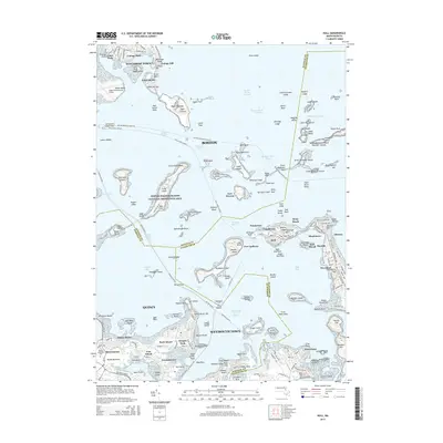
2015 Map of Hull
USGS Topo · Published 2015About this map
The maritime defenses of Boston Harbor Islands National Recreation Area dominate this coastal landscape, where a network of historic fortifications once guarded the approach to the city. From the northern reaches at Fort Dawes on Deer Island down to Fort Andrews on Peddocks Island and Fort Revere on the Hull peninsula, these sites mark the strategic military geography of the Massachusetts coast. The intricate archipelago is bisected by vital shipping lanes like President Roads and Nantasket Roads, while Logan International Airport occupies the northwestern corner. On the mainland, the residential patterns of Quincy and Weymouth Town are clearly defined, showing established neighborhoods like Germantown, Merrymount, and Houghs Neck. Historical researchers will find significant detail in the placement of landmarks such as Telegraph Hill and the Mount Wollaston Cem, illustrating the evolution of South Shore settlement from defensive outposts to dense suburban communities.
Find a feature on this map
213 named features on this map. Tap any name to fly to it.
Don’t see what you’re looking for? This feature index may not catch every label — zoom into the map to look around manually.
Map Details
Editions of this 2015 Hull Map
This is the sole edition of this map. No revisions or reprints were ever made.
Other maps of this area

1885 · Abington
USGS Topo · 1:62,500

1886 · Dedham
USGS Topo · 1:62,500

1888 · Abington
USGS Topo · 1:62,500

1892 · Boston Bay
USGS Topo · 1:62,500

1893 · Abington
USGS Topo · 1:62,500

1893 · Boston
USGS Topo · 1:62,500

1894 · Dedham
USGS Topo · 1:62,500

1903 · Boston
USGS Topo · 1:62,500

1903 · Boston Bay
USGS Topo · 1:62,500

1919 · Dedham
USGS Topo · 1:62,500