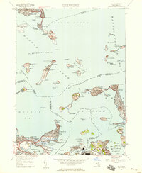
1949 Map of Hull
USGS Topo · Published 1958About this map
Boston Harbor is defined by a strategic network of defensive fortifications and civil institutions in this late-1940s survey. The landscape is dominated by the militarization of the outer islands, where Ft Strong, Ft Warren, and Ft Standish guard the shipping lanes of President Roads and The Narrows. Along the northern edge, the early footprint of Logan International Airport appears beside Winthrop, while Deer Island houses a large House of Correction.
Find a feature on this map
122 named features on this map. Tap any name to fly to it.
Don’t see what you’re looking for? This feature index may not catch every label — zoom into the map to look around manually.
Map Details
Editions of this 1949 Hull Map
This is the sole edition of this map. No revisions or reprints were ever made.
Other maps of this area

1885 · Abington
USGS Topo · 1:62,500

1886 · Dedham
USGS Topo · 1:62,500

1888 · Abington
USGS Topo · 1:62,500

1892 · Boston Bay
USGS Topo · 1:62,500

1893 · Abington
USGS Topo · 1:62,500

1893 · Boston
USGS Topo · 1:62,500

1894 · Dedham
USGS Topo · 1:62,500

1903 · Boston
USGS Topo · 1:62,500

1903 · Boston Bay
USGS Topo · 1:62,500

1919 · Dedham
USGS Topo · 1:62,500