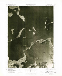
1977 Map of Hull
USGS Topo · Published 1980About this map
Hull and its slender peninsula dominate this 1977 aerial orthophotograph, providing a detailed visual record of the coastal Massachusetts shoreline just before the 1980s. The map captures the dense residential patterns and harbor infrastructure of Winthrop in the north and the industrial and suburban interfaces of Weymouth and Hingham to the south. Unlike traditional line-drawn maps, this photo-quadrangle reveals the exact texture of the landscape, from the tidal flats along the Weir River and Back River to the complex network of islands scattered across Massachusetts Bay. The maritime geography is particularly clear, showing the deep channels of the Fore River and the exposed reaches of Broad Sound, making it an essential document for understanding the physical state of the Boston Harbor islands and surrounding coastal towns at the end of the 1970s.
Find a feature on this map
9 named features on this map. Tap any name to fly to it.
Don’t see what you’re looking for? This feature index may not catch every label — zoom into the map to look around manually.
Map Details
Editions of this 1977 Hull Map
This is the sole edition of this map. No revisions or reprints were ever made.
Other maps of this area

1885 · Abington
USGS Topo · 1:62,500

1886 · Dedham
USGS Topo · 1:62,500

1888 · Abington
USGS Topo · 1:62,500

1892 · Boston Bay
USGS Topo · 1:62,500

1893 · Abington
USGS Topo · 1:62,500

1893 · Boston
USGS Topo · 1:62,500

1894 · Dedham
USGS Topo · 1:62,500

1903 · Boston
USGS Topo · 1:62,500

1903 · Boston Bay
USGS Topo · 1:62,500

1919 · Dedham
USGS Topo · 1:62,500