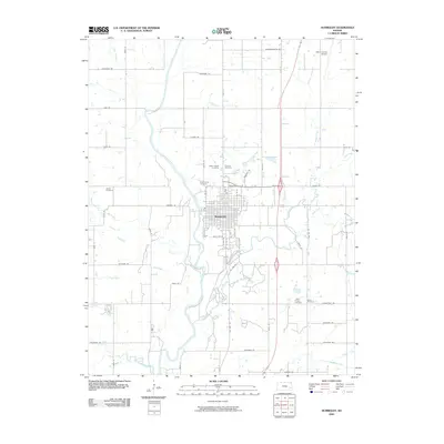
2009 Map of Humboldt
USGS Topo · Published 2009About this map
The Humboldt townsite sits at a bend in the Neosho River, anchoring a landscape defined by a grid of named rural roads and numerous family and parish burial grounds. This 2009 survey highlights a concentration of historical sites including Saint Joseph Cemetery, Dewitt Cemetery, and the Evan Young Cemetery, which serve as vital markers for local genealogical research in this part of Allen County. The surrounding prairie is drained by a network of waterways with distinctive names such as Vegetarian Creek, Bloody Run, and Onion Creek. North of the main settlement, the Allen County Airport and a series of alphabetically and geographically named routes like Massachusetts Rd and Louisiana Rd define the modern infrastructure. The path of Old Hwy 169 runs parallel to the river, tracing the older transportation corridors that once linked these Kansas farmsteads.
Find a feature on this map
37 named features on this map. Tap any name to fly to it.
Don’t see what you’re looking for? This feature index may not catch every label — zoom into the map to look around manually.
Map Details
Editions of this 2009 Humboldt Map
This is the sole edition of this map. No revisions or reprints were ever made.
Other maps of this area

1886 · Fredonia
USGS Topo · 1:125,000

1886 · Iola
USGS Topo · 1:125,000

1893 · Iola
USGS Topo · 1:125,000

1894 · Fredonia
USGS Topo · 1:125,000

1904 · Iola
USGS Topo · 1:125,000

1938 · Altoona
USGS Topo · 1:62,500

1939 · Altoona
USGS Topo · 1:48,000

1943 · Altoona
USGS Topo · 1:62,500

1947 · Joplin
USGS Topo · 1:250,000

1949 · Joplin
USGS Topo · 1:250,000