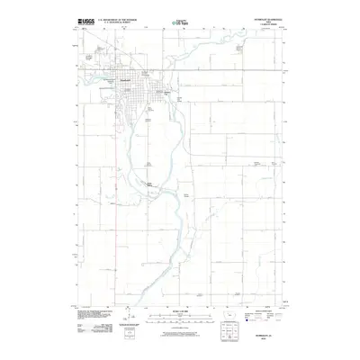
2010 Map of Humboldt
USGS Topo · Published 2010About this map
The Des Moines River and its East Fork converge just south of Humboldt and Dakota City, creating a landscape defined by water management and local industry in north-central Iowa. This survey documents the infrastructure supporting these sister cities, from the Humboldt Post Office and Humboldt County Fairgrounds to the Humboldt Fish Hatchery and the Joe Reasoner Dam on Lake Nokomis. The surrounding rural township is marked by a high density of burial grounds, including Indian Mound Cemetery, Union Cemetery, and Oakwood Cemetery, which provide significant points of interest for genealogical research.
Find a feature on this map
55 named features on this map. Tap any name to fly to it.
Don’t see what you’re looking for? This feature index may not catch every label — zoom into the map to look around manually.
Map Details
Editions of this 2010 Humboldt Map
This is the sole edition of this map. No revisions or reprints were ever made.
Other maps of this area

1923 · Fort Dodge
USGS Topo · 1:62,500

1954 · Fort Dodge
USGS Topo · 1:250,000

1957 · Fort Dodge
USGS Topo · 1:250,000

1958 · Fort Dodge
USGS Topo · 1:250,000

1972 · Livermore
USGS Topo · 1:24,000
1972 · Hardy
USGS Topo · 1:24,000
1979 · Fort Dodge North
USGS Topo · 1:24,000
1979 · Thor
USGS Topo · 1:24,000

1979 · Humboldt
USGS Topo · 1:24,000

1979 · Clare
USGS Topo · 1:24,000