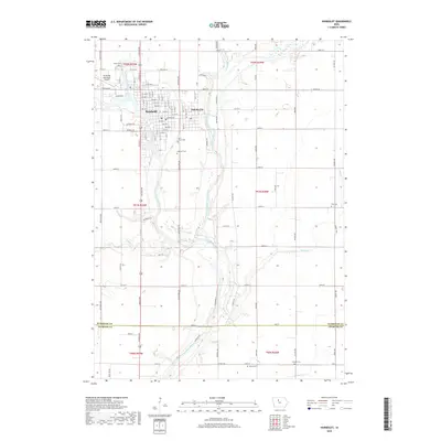
2018 Map of Humboldt
USGS Topo · Published 2018About this map
Humboldt and Dakota City sit at the geographic heart of this 2018 survey, where the East Fork Des-Moines-River converges with the main stem of the Des Moines River. The landscape is defined by the winding river valleys and an extensive network of managed water systems, including Drainage Ditch Number 33 and Drainage Ditch Number 25, which support the surrounding agricultural lands. This modern record of the region captures the interface between the twin towns and the water-managed plains of the Humboldt and Webster county line.
Find a feature on this map
91 named features on this map. Tap any name to fly to it.
Don’t see what you’re looking for? This feature index may not catch every label — zoom into the map to look around manually.
Map Details
Editions of this 2018 Humboldt Map
This is the sole edition of this map. No revisions or reprints were ever made.
Other maps of this area

1923 · Fort Dodge
USGS Topo · 1:62,500

1954 · Fort Dodge
USGS Topo · 1:250,000

1957 · Fort Dodge
USGS Topo · 1:250,000

1958 · Fort Dodge
USGS Topo · 1:250,000

1972 · Livermore
USGS Topo · 1:24,000
1972 · Hardy
USGS Topo · 1:24,000
1979 · Fort Dodge North
USGS Topo · 1:24,000
1979 · Thor
USGS Topo · 1:24,000

1979 · Humboldt
USGS Topo · 1:24,000

1979 · Clare
USGS Topo · 1:24,000