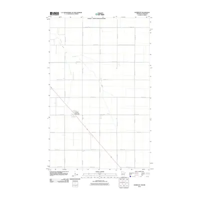
2010 Map of Humboldt
USGS Topo · Published 2010About this map
The Canada - United States Boundary defines the northern edge of this Red River Valley landscape, where the international border meets the far northwest corner of Minnesota. The small community of Humboldt serves as the primary focal point, anchored by the Humboldt Post Office and a network of agricultural section roads. The meandering path of the Joe River cuts across the flat terrain, providing a natural break in the geometric grid of township and county highways. This 2010 survey illustrates the sparse, late-twentieth-century settlement pattern characteristic of Kittson County, where large-scale farming and transportation corridors like County Hwy-16 dominate the geography. The map captures the quiet isolation of a border town whose layout remains defined by its proximity to the Canadian frontier.
Find a feature on this map
27 named features on this map. Tap any name to fly to it.
Don’t see what you’re looking for? This feature index may not catch every label — zoom into the map to look around manually.
Map Details
Editions of this 2010 Humboldt Map
This is the sole edition of this map. No revisions or reprints were ever made.
Other maps of this area

1939 · Pembina
USGS Topo · 1:62,500

1941 · Hallock
USGS Topo · 1:62,500

1941 · Pembina
USGS Topo · 1:62,500

1952 · Thief River Falls
USGS Topo · 1:250,000

1956 · Thief River Falls
USGS Topo · 1:250,000

1957 · Thief River Falls
USGS Topo · 1:250,000

1967 · Thief River Falls
USGS Topo · 1:250,000
1972 · Joliette
USGS Topo · 1:24,000
1972 · Pembina
USGS Topo · 1:24,000
1974 · Humboldt
USGS Topo · 1:24,000