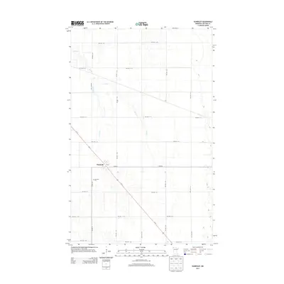
2013 Map of Humboldt
USGS Topo · Published 2013About this map
Humboldt sits as the primary settlement in this corner of Kittson County, characterized by a highly organized grid of township roads that bisect the flat Red River Valley terrain. The landscape is defined by its agricultural layout, where Joe River and the meandering Salt Coulee provide the principal natural drainage across the expansive prairie. This 2013 survey illustrates the modern transportation corridor where Us-75 cuts diagonally through the section lines, linking the small community and its Po to the broader regional network. For those tracing local heritage, the Humboldt Cem remains a significant landmark southwest of the town center, while the dense network of routes like Co Hwy-6 and Co Hwy-16 reflects the area's continued reliance on a robust rural infrastructure for its farming economy.
Find a feature on this map
25 named features on this map. Tap any name to fly to it.
Don’t see what you’re looking for? This feature index may not catch every label — zoom into the map to look around manually.
Map Details
Editions of this 2013 Humboldt Map
This is the sole edition of this map. No revisions or reprints were ever made.
Other maps of this area

1939 · Pembina
USGS Topo · 1:62,500

1941 · Hallock
USGS Topo · 1:62,500

1941 · Pembina
USGS Topo · 1:62,500

1952 · Thief River Falls
USGS Topo · 1:250,000

1956 · Thief River Falls
USGS Topo · 1:250,000

1957 · Thief River Falls
USGS Topo · 1:250,000

1967 · Thief River Falls
USGS Topo · 1:250,000
1972 · Joliette
USGS Topo · 1:24,000
1972 · Pembina
USGS Topo · 1:24,000
1974 · Humboldt
USGS Topo · 1:24,000