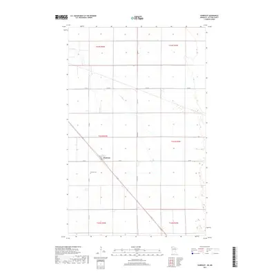
2019 Map of Humboldt
USGS Topo · Published 2019About this map
Humboldt sits as the central settlement in this far-northern corner of Kittson County, defined by the precise section lines of the Public Land Survey System. The landscape is characterized by its agricultural geometry and vital water management features like Salt Coulee and the meandering Joe River. Local infrastructure is anchored by the township's namesake Humboldt Cem and a network of county roads including Co RD 6 and Co RD 55 that service the surrounding farmsteads. The diagonal path of 1st Ave cuts across the gridded sections, providing a direct link through the township's core. This survey illustrates the persistent rural character of the Red River Valley region, where drainage patterns and road placements remain fundamentally tied to the original nineteenth-century land partitions.
Find a feature on this map
16 named features on this map. Tap any name to fly to it.
Don’t see what you’re looking for? This feature index may not catch every label — zoom into the map to look around manually.
Map Details
Editions of this 2019 Humboldt Map
This is the sole edition of this map. No revisions or reprints were ever made.
Other maps of this area

1939 · Pembina
USGS Topo · 1:62,500

1941 · Hallock
USGS Topo · 1:62,500

1941 · Pembina
USGS Topo · 1:62,500

1952 · Thief River Falls
USGS Topo · 1:250,000

1956 · Thief River Falls
USGS Topo · 1:250,000

1957 · Thief River Falls
USGS Topo · 1:250,000

1967 · Thief River Falls
USGS Topo · 1:250,000
1972 · Joliette
USGS Topo · 1:24,000
1972 · Pembina
USGS Topo · 1:24,000
1974 · Humboldt
USGS Topo · 1:24,000