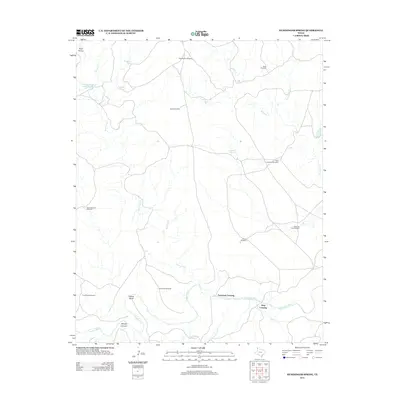
2012 Map of Humdinger Spring
USGS Topo · Published 2012About this map
The Canadian River meanders across this Panhandle landscape, defining a network of drainages and crossings in Oldham County. The map captures a ranching-focused environment where water access is paramount, evidenced by the numerous named windmills such as High Lonesome Windmill and Pedarosa Vats Windmill that dot the territory. Notable river access points include Partwood Crossing and Strip Crossing, which suggest historic routes through the river valley.
Find a feature on this map
25 named features on this map. Tap any name to fly to it.
Don’t see what you’re looking for? This feature index may not catch every label — zoom into the map to look around manually.
Map Details
Editions of this 2012 Humdinger Spring Map
This is the sole edition of this map. No revisions or reprints were ever made.
Other maps of this area

1954 · Tucumcari
USGS Topo · 1:250,000

1958 · Tucumcari
USGS Topo · 1:250,000

1966 · Alamocitos Camp
USGS Topo · 1:24,000

1966 · Big George Tank
USGS Topo · 1:24,000

1966 · Vat Camp
USGS Topo · 1:24,000

1971 · Romero SE
USGS Topo · 1:24,000

1971 · Proctor Ranch
USGS Topo · 1:24,000

1971 · Spring Creek Ranch
USGS Topo · 1:24,000

1971 · Many Post Camp
USGS Topo · 1:24,000
1971 · Humdinger Spring
USGS Topo · 1:24,000