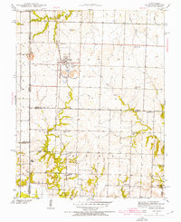
1940 Map of Hume
USGS Topo · Published 1954About this map
Hume serves as the primary hub of this rural landscape along the Missouri-Kansas border, where the Kansas City Southern railroad dictates the local geography. Surveyed just before the mid-century, the map reveals a high density of rural schoolhouses and neighborhood churches, reflecting a decentralized community structure typical of the era. Educational nodes like Brush College Sch, Prairie Union Sch, and the uniquely named Hume Gem are scattered across the terrain, serving family farms located between Duncan Creek and Pryor Creek. To the south, the settlement of Amos sits near the Lawrence Cem, while the landscape is punctuated by landmarks such as Rocky Mound. This survey provides a precise record of the road networks and watercourses, including the Little Osage River, before more modern consolidation changed the rural school system.
Find a feature on this map
29 named features on this map. Tap any name to fly to it.
Don’t see what you’re looking for? This feature index may not catch every label — zoom into the map to look around manually.
Map Details
Editions of this 1940 Hume Map
3 editions found

Other maps of this area

1884 · Fort Scott
USGS Topo · 1:125,000

1886 · Nevada
USGS Topo · 1:125,000

1886 · Fort Scott
USGS Topo · 1:125,000

1887 · Butler
USGS Topo · 1:125,000

1887 · Mound City
USGS Topo · 1:125,000

1893 · Fort Scott
USGS Topo · 1:125,000

1893 · Mound City
USGS Topo · 1:125,000

1894 · Butler
USGS Topo · 1:125,000

1894 · Nevada
USGS Topo · 1:125,000

1937 · New Home
USGS Topo · 1:24,000