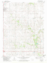
1982 Map of Humeston
USGS Topo · Published 1983About this map
Humeston anchors this Wayne County landscape, situated at the junction of the Burlington Northern and the corridors of the Old Railroad Grade. The town's grid is clearly defined, featuring a sewage disposal pond to the northwest and The Cinder Path following the former rail line toward the northeast. This 1982 map reveals a rural economy structured around small settlements like Cambria and the locality of Fairall, with a landscape segmented into the townships of Richman, Washington, Clay, and Benton. Significant local history is preserved in the distribution of family and community burial grounds, including Cambria, Kirby, Rush, and Greenlee cemeteries. The terrain is drained by the South Fork Chariton River and its tributaries, such as Ninemile Creek and Wolf Creek, which carve winding paths through the agricultural fields.
Find a feature on this map
21 named features on this map. Tap any name to fly to it.
Don’t see what you’re looking for? This feature index may not catch every label — zoom into the map to look around manually.
Map Details
Editions of this 1982 Humeston Map
This is the sole edition of this map. No revisions or reprints were ever made.
Other maps of this area

1934 · Humeston
USGS Topo · 1:48,000

1937 · Corydon
USGS Topo · 1:62,500

1954 · Centerville
USGS Topo · 1:250,000

1957 · Centerville
USGS Topo · 1:250,000

1958 · Centerville
USGS Topo · 1:250,000

1964 · Woodland
USGS Topo · 1:24,000

1964 · Allerton
USGS Topo · 1:24,000

1964 · Clio
USGS Topo · 1:24,000
1965 · Le Roy
USGS Topo · 1:24,000
1965 · Garden Grove
USGS Topo · 1:24,000