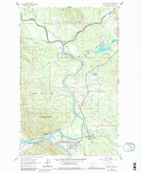
1962 Map of Hungry Horse
USGS Topo · Published 1983About this map
The confluence of the Middle Fork Flathead River and the South Fork Flathead River anchors this landscape, marking the southwestern gateway to Glacier National Park. In the early 1960s, the riverside communities of Hungry Horse, Coram, and Martin City served as vital centers for transportation and mountain access. The Burlington Northern railroad winds through the narrow passage of Badrock Canyon, following the river's path toward the park boundary. Higher elevations are dominated by Teakettle Mountain and the Apgar Mountains, where pack trails and jeep trails indicate a rugged interior used for forest management and recreation. The presence of the Flathead River Ranger Station and various gaging stations underscores the importance of monitoring these critical alpine waterways during a period of expanding recreational interest in the Flathead National Forest.
Find a feature on this map
29 named features on this map. Tap any name to fly to it.
Don’t see what you’re looking for? This feature index may not catch every label — zoom into the map to look around manually.
Map Details
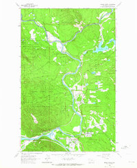
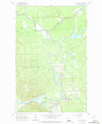
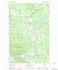
Editions of this 1962 Hungry Horse Map
4 editions found
Other maps of this area

1904 · Chief Mountain
USGS Topo · 1:125,000

1906 · Kintla Lakes
USGS Topo · 1:125,000

1914 · Nyack
USGS Topo · 1:125,000

1938 · Chief Mountain
USGS Topo · 1:125,000

1938 · Kintla Lakes
USGS Topo · 1:125,000

1943 · Kalispell
USGS Topo · 1:125,000

1957 · Kalispell
USGS Topo · 1:250,000

1960 · Kalispell
USGS Topo · 1:250,000

1960 · Cut Bank
USGS Topo · 1:250,000

1961 · Kalispell
USGS Topo · 1:250,000