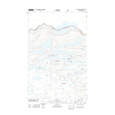
2013 Map of Hungry Jack Lake
USGS Topo · Published 2013About this map
The international border between Canada and the United States runs through the northern waters of Rose Lake, marking the northern edge of this remote wilderness in Cook County, Minnesota. This portion of the Superior National Forest is defined by a dense network of glacial lakes and portages, including Hungry Jack Lake and the long, narrow stretches of Daniels Lake and Duncan Lake. Local recreation and forest management are anchored at sites like Hungry Jack Lodge and Campground and Flour Lake Campground, while the Bearskin Lookout Tower stands as a sentinel over the surrounding timber and water. Access to these backcountry destinations is provided by narrow forest routes such as Lima Grade, Hungry Jack Road, and Menogyn Trail, which navigate the elevation changes near landmarks like Honeymoon Bluff.
Find a feature on this map
59 named features on this map. Tap any name to fly to it.
Don’t see what you’re looking for? This feature index may not catch every label — zoom into the map to look around manually.
Map Details
Editions of this 2013 Hungry Jack Lake Map
This is the sole edition of this map. No revisions or reprints were ever made.
Other maps of this area

1919 · Brule Lake
USGS Topo · 1:62,500

1954 · Two Harbors
USGS Topo · 1:250,000

1957 · Two Harbors
USGS Topo · 1:250,000

1957 · Quetico
USGS Topo · 1:250,000

1958 · Two Harbors
USGS Topo · 1:250,000

1959 · Pine Mountain
USGS Topo · 1:24,000

1959 · Lima Mountain
USGS Topo · 1:24,000

1959 · Hungry Jack Lake
USGS Topo · 1:24,000

1959 · Crocodile Lake
USGS Topo · 1:24,000
1960 · South Lake
USGS Topo · 1:24,000