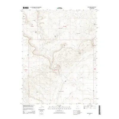
2014 Map of Hunt Draw
USGS Topo · Published 2014About this map
The San Rafael Swell dominates this portion of Emery County, where the desert landscape is defined by dramatic uplift and erosion. The Muddy Cr carves a winding path through the center of the sheet, creating deep drainage features like The Chute and passing near The Pasture. To the east, the sharp hogbacks of the San Rafael Reef and the North Caineville Reef create formidable natural barriers, separated by the eponymous Hunt Draw. Smaller geologic landmarks such as Sy Butte and Chimney Canyon punctuate the surrounding Keesle Country. Access to this remote terrain is limited to primitive routes like Wild Horse Rd, which traces the eastern edge of the swell near the Moroni Slopes. The map also captures several isolated water sources critical to this arid region, including Bullberry Spring and the Salt Wash drainage system.
Find a feature on this map
25 named features on this map. Tap any name to fly to it.
Don’t see what you’re looking for? This feature index may not catch every label — zoom into the map to look around manually.
Map Details
Editions of this 2014 Hunt Draw Map
This is the sole edition of this map. No revisions or reprints were ever made.
Other maps of this area

1885 · San Rafael
USGS Topo · 1:250,000

1885 · Fish Lake
USGS Topo · 1:250,000

1896 · Fish Lake
USGS Topo · 1:250,000

1952 · Wild Horse
USGS Topo · 1:62,500

1953 · Emery 4 NE
USGS Topo · 1:24,000

1953 · Emery 4 SE
USGS Topo · 1:24,000

1954 · Stinking Spring Creek 3 NW
USGS Topo · 1:24,000

1954 · Stinking Spring Creek 3 SE
USGS Topo · 1:24,000

1954 · Stinking Spring Creek 3 SW
USGS Topo · 1:24,000
1954 · Stinking Spring Creek 3 NE
USGS Topo · 1:24,000