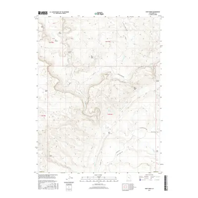
2017 Map of Hunt Draw
USGS Topo · Published 2017About this map
The San Rafael Reef and the San Rafael Swell define this portion of Emery County, where the desert landscape is carved by seasonal drainages and ancient geological uplifts. The map detail highlights the complex erosion patterns through Chimney Canyon and Cistern Canyon, leading into the deep recesses of Johns Hole and Segers Hole. This area, primarily managed by the BLM, is crossed by a network of rudimentary travel routes including the Behind the Reef Road and the path from Moab to Boulder Town. Water, though scarce, is marked by features such as Bullberry Spring and the winding course of Muddy Cr. The topography shifts dramatically from the high point of Sy Butte down toward the drainage of Hunt Draw, illustrating the stark transition between the high desert plateaus and the canyon floor.
Find a feature on this map
30 named features on this map. Tap any name to fly to it.
Don’t see what you’re looking for? This feature index may not catch every label — zoom into the map to look around manually.
Map Details
Editions of this 2017 Hunt Draw Map
This is the sole edition of this map. No revisions or reprints were ever made.
Other maps of this area

1885 · San Rafael
USGS Topo · 1:250,000

1885 · Fish Lake
USGS Topo · 1:250,000

1896 · Fish Lake
USGS Topo · 1:250,000

1952 · Wild Horse
USGS Topo · 1:62,500

1953 · Emery 4 NE
USGS Topo · 1:24,000

1953 · Emery 4 SE
USGS Topo · 1:24,000

1954 · Stinking Spring Creek 3 NW
USGS Topo · 1:24,000

1954 · Stinking Spring Creek 3 SE
USGS Topo · 1:24,000

1954 · Stinking Spring Creek 3 SW
USGS Topo · 1:24,000
1954 · Stinking Spring Creek 3 NE
USGS Topo · 1:24,000