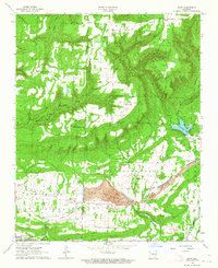
1963 Map of Hunt
USGS Topo · Published 1964About this map
The industrial and natural divide of Franklin and Johnson counties is sharply defined by the massive footprint of the Utah Strip Mine in the southern lowlands. This mid-century landscape transitions from the heavy coal and gravel extraction operations near Hunt and Edna to the high, wooded ridges of the Ozark National Forest in the north. The topography is dotted with a remarkably high density of small family and community burial grounds, including Dowd Cem, Hailey Cem, and Oak Grove Cem, providing a detailed record of the area's rural genealogy.
Find a feature on this map
45 named features on this map. Tap any name to fly to it.
Don’t see what you’re looking for? This feature index may not catch every label — zoom into the map to look around manually.
Map Details
Editions of this 1963 Hunt Map
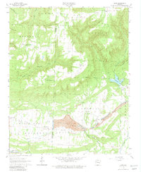
2 editions found
Other maps of this area

1879 · Cravens
USGS Topo · 1:62,500

1887 · Magazine Mountain #1
USGS Topo · 1:62,500

1887 · Magazine Mountain #2
USGS Topo · 1:62,500

1887 · Watalula
USGS Topo · 1:62,500

1887 · Magazine Mountain
USGS Topo · 1:62,500

1890 · Magazine Mountain
USGS Topo · 1:125,000

1906 · Batson
USGS Topo · 1:62,500

1939 · Watalula
USGS Topo · 1:62,500

1956 · Russellville
USGS Topo · 1:250,000

1961 · Coal Hill
USGS Topo · 1:24,000