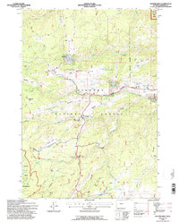
1993 Map of Hunter Mesa
USGS Topo · Published 1997About this map
Bighorn National Forest lands dominate this high-altitude landscape in Johnson County, defined by a series of open mountain meadows or parks including Buffalo Park, Schoolhouse Park, and Elgin Park. The map documents a working landscape of the early 1990s, where recreational sites like Paradise Ranch and South Park Resort coexist with traditional ranching infrastructure such as the Hunter Corral and French Creek Cow Camp. An Old Military Reservation Boundary cuts north-south across the eastern sections, providing a glimpse into the region's historical land management and defense history. The complex hydrology of the Big Horns is evident in the numerous drainages such as Clear Creek and Hondo Creek that carve through the Hunter Mesa. This survey also marks specialized points of interest like the Hunter Work Center, The Pines, and the County Youth Camp, situated along the Cloud Peak Skyway.
Find a feature on this map
47 named features on this map. Tap any name to fly to it.
Don’t see what you’re looking for? This feature index may not catch every label — zoom into the map to look around manually.
Map Details
Editions of this 1993 Hunter Mesa Map
This is the sole edition of this map. No revisions or reprints were ever made.
Other maps of this area

1899 · Cloud peak
USGS Topo · 1:125,000

1900 · Fort McKinney
USGS Topo · 1:125,000

1901 · Cloud Peak
USGS Topo · 1:125,000

1903 · Fort McKinney
USGS Topo · 1:125,000

1955 · Sheridan
USGS Topo · 1:250,000

1958 · Sheridan
USGS Topo · 1:250,000

1962 · Sheridan
USGS Topo · 1:250,000

1967 · Lake De Smet West
USGS Topo · 1:24,000
1967 · Willow Park Reservoir
USGS Topo · 1:24,000

1967 · Caribou Creek
USGS Topo · 1:24,000