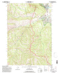
1991 Map of Hunter Peak
USGS Topo · Published 1997About this map
Shoshone National Forest defines the character of this 1991 survey, which captures the remote reaches of the Absaroka Range before the turn of the millennium. The northeastern corner contains the most concentrated human activity, centered around the Crandall Ranger Station and the Clarks Fork Scenic Highway where it meets the Yellowstone River. These landmarks serve as the gateway to a vast backcountry network of paths, including the Crandall Trail and Papoose Trail.
Find a feature on this map
24 named features on this map. Tap any name to fly to it.
Don’t see what you’re looking for? This feature index may not catch every label — zoom into the map to look around manually.
Map Details
Editions of this 1991 Hunter Peak Map
This is the sole edition of this map. No revisions or reprints were ever made.
Other maps of this area

1896 · Crandall Creek
USGS Topo · 1:125,000

1899 · Crandall
USGS Topo · 1:125,000

1955 · Cody
USGS Topo · 1:250,000

1956 · Sunlight Peak
USGS Topo · 1:62,500

1956 · Beartooth Butte
USGS Topo · 1:62,500

1956 · Pilot Peak
USGS Topo · 1:62,500

1956 · Dead Indian Peak
USGS Topo · 1:62,500

1958 · Cody
USGS Topo · 1:250,000

1962 · Cody
USGS Topo · 1:250,000

1980 · Cody
USGS Topo · 1:100,000