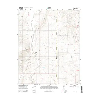
2014 Map of Hunters Point
USGS Topo · Published 2014About this map
Black Creek flows through the central corridor of this high-desert landscape on the Arizona-New Mexico border, anchoring the community of Black Creek Valley. The terrain is defined by dramatic elevation changes, notably around the landmark Hunters Point, where springs and ponds such as Hunters Point Spring and Tse Notahs Pond provide essential water sources in an otherwise arid environment. This 2014 survey by the U.S. Geological Survey illustrates a modern infrastructure of Bureau of Indian Affairs routes, including Bia-12 and Bia-123, which connect the scattered homesteads and settlements of the Fort Defiance Agency. A localized industrial footprint is evident near the southern hills at the Gravel Pit, while the northern reaches are accessed via El Paso Station Rd and Logan Rd, reflecting the long-standing transportation patterns of Apache and McKinley counties.
Find a feature on this map
32 named features on this map. Tap any name to fly to it.
Don’t see what you’re looking for? This feature index may not catch every label — zoom into the map to look around manually.
Map Details
Editions of this 2014 Hunters Point Map
This is the sole edition of this map. No revisions or reprints were ever made.
Other maps of this area

1886 · Wingate
USGS Topo · 1:250,000

1886 · Fort Defiance
USGS Topo · 1:250,000

1892 · Fort Defiance
USGS Topo · 1:250,000

1892 · Wingate
USGS Topo · 1:250,000

1954 · Gallup
USGS Topo · 1:250,000

1955 · Zith-Tusayan Butte 4 NW
USGS Topo · 1:24,000

1955 · Zith-Tusayan Butte 4 NE
USGS Topo · 1:24,000

1958 · Gallup
USGS Topo · 1:250,000

1959 · Gallup
USGS Topo · 1:250,000

1962 · Gallup
USGS Topo · 1:250,000
Featured Places
- Fort Defiance Agency
- Eastern Navajo Agency, NM
- Hunters Point, Fort Defiance Agency
- McKinley County, NM
- Apache County, AZ