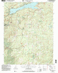
2004 Map of Huntington Lake
USGS Topo · Published 2007About this map
Huntington Lake serves as the focal point of this mountain landscape, which captures the intersection of mid-century hydroelectric infrastructure and modern recreation. The settlement of Big Creek and its associated Powerhouse No. 1 highlight the region's industrial utility, while the surrounding Sierra National Forest is mapped with extensive detail regarding high-altitude recreation. The map identifies specific summer developments like Cedar Crest and Dowville, alongside dedicated winter sites including Coyote Snow Park and Tamarack Snow Park.
Find a feature on this map
57 named features on this map. Tap any name to fly to it.
Don’t see what you’re looking for? This feature index may not catch every label — zoom into the map to look around manually.
Map Details
Editions of this 2004 Huntington Lake Map
This is the sole edition of this map. No revisions or reprints were ever made.
Other maps of this area

1904 · Kaiser
USGS Topo · 1:125,000

1947 · Mariposa
USGS Topo · 1:250,000

1948 · Mariposa
USGS Topo · 1:250,000

1953 · Huntington Lake
USGS Topo · 1:62,500

1953 · Shaver Lake
USGS Topo · 1:62,500

1953 · Shuteye Peak
USGS Topo · 1:62,500

1953 · Kaiser Peak
USGS Topo · 1:62,500

1957 · Mariposa
USGS Topo · 1:250,000

1963 · Mariposa
USGS Topo · 1:250,000

1980 · Shaver Lake
USGS Topo · 1:100,000