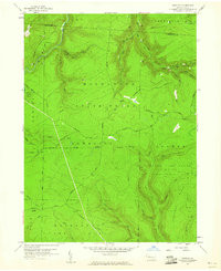
1959 Map of Huntley
USGS Topo · Published 1960About this map
Moshannon State Forest dominates this landscape on the border of Elk and Clearfield counties, where the high plateaus of Pennsylvania are etched by deep drainages like Medix Run and Little Laurel Run. In the late 1950s, this region was a focus of natural resource extraction, evidenced by the numerous Gas Well labels and several Mines scattered across the ridges. The terrain is defined by its recreation and conservation land, including a portion of Parker Dam State Park and the expansive Goshen State Game Lands No 94. Historic transit routes such as the Caledonia Pike and Huntley Road follow the contours of the high ground, providing access to landmarks like Panther Rocks and the distinctive spine of Chestnut Ridge. The map illustrates a transitional period when energy infrastructure, such as the prominent Pipeline corridors, began to cross these protected forest lands.
Find a feature on this map
42 named features on this map. Tap any name to fly to it.
Don’t see what you’re looking for? This feature index may not catch every label — zoom into the map to look around manually.
Map Details
Editions of this 1959 Huntley Map
3 editions found
Other maps of this area

1929 · Clearfield
USGS Topo · 1:48,000

1929 · Penfield
USGS Topo · 1:62,500

1932 · Clearfield
USGS Topo · 1:62,500

1932 · Penfield
USGS Topo · 1:62,500

1941 · Benezette
USGS Topo · 1:62,500

1941 · Ridgway
USGS Topo · 1:62,500

1943 · Benezette
USGS Topo · 1:62,500

1944 · Ridgway
USGS Topo · 1:62,500

1957 · Warren
USGS Topo · 1:250,000

1958 · Warren
USGS Topo · 1:250,000