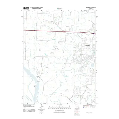
2011 Map of Huntsdale
USGS Topo · Published 2011About this map
Perche Creek and Hinkson Creek dominate the central drainage of this Missouri landscape, flowing south toward a prominent bend in the Missouri River. The river's path is marked by distinctive geographical features like Searcys Bend and Tadpole Island, illustrating the shifting alluvial environment near Huntsdale and McBaine. This 2011 survey captures the interface between the western expansion of Columbia and the rural agricultural tracts to its west. Local history is preserved through several family and community burial grounds, including Sugar Creek Cemetery, Valley Springs Cemetery, and Mount Nebo Cemetery. Further north, the settlement of Midway sits at a crossroads, while suburban developments begin to reach toward Brushwood Lake and the various branches of the creek systems. The map detail reflects a transition from river-bottom farming to more densely planned neighborhoods on the city's periphery.
Find a feature on this map
96 named features on this map. Tap any name to fly to it.
Don’t see what you’re looking for? This feature index may not catch every label — zoom into the map to look around manually.
Map Details
Editions of this 2011 Huntsdale Map
This is the sole edition of this map. No revisions or reprints were ever made.
Other maps of this area

1886 · Jefferson City
USGS Topo · 1:125,000

1888 · Boonville
USGS Topo · 1:125,000

1890 · Moberly
USGS Topo · 1:125,000

1890 · Glasgow
USGS Topo · 1:125,000

1894 · Jefferson City
USGS Topo · 1:125,000

1917 · Sturgeon
USGS Topo · 1:62,500

1935 · Columbia
USGS Topo · 1:24,000

1940 · Columbia
USGS Topo · 1:24,000

1947 · Jefferson City
USGS Topo · 1:250,000
1948 · Columbia
USGS Topo · 1:24,000