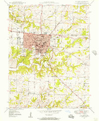
1948 Map of Columbia
USGS Topo · Published 1956About this map
University of Missouri dominates the southern part of the city in this late-1940s survey, surrounded by the collegiate grounds of Stephens College and Christian College. The urban core is detailed with institutional landmarks like the Armory, County Hospital, and State Hospital, while the Wabash RR cuts through the northern reaches near Moores Lake. Beyond the city limits, the landscape transitions into a mix of agricultural land and scattered industrial sites, including a Quarry and various inactive mines near Zaring Sch.
Find a feature on this map
61 named features on this map. Tap any name to fly to it.
Don’t see what you’re looking for? This feature index may not catch every label — zoom into the map to look around manually.
Map Details
Editions of this 1948 Columbia Map
2 editions found
Other maps of this area

1886 · Jefferson City
USGS Topo · 1:125,000

1890 · Moberly
USGS Topo · 1:125,000

1894 · Jefferson City
USGS Topo · 1:125,000

1917 · Sturgeon
USGS Topo · 1:62,500

1935 · Columbia
USGS Topo · 1:24,000

1940 · Columbia
USGS Topo · 1:24,000

1944 · Millersburg
USGS Topo · 1:62,500

1945 · Centralia
USGS Topo · 1:62,500

1946 · Millersburg
USGS Topo · 1:62,500

1947 · Jefferson City
USGS Topo · 1:250,000