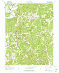
1965 Map of Huron
USGS Topo · Published 1966About this map
The Baltimore and Ohio railroad corridor anchors the landscape of southern Indiana, threading through the hills of the Martin State Forest and Hoosier National Forest. This 1965 revision details a rural environment defined by sharp relief and engineering, notably at the Willow Tunnel and the winding course of Beaver Creek. The settlement of Huron serves as a local hub near the boundary of Martin and Lawrence Counties, while smaller outposts like Willow Valley and Bonds are scattered among the ridges.
Find a feature on this map
36 named features on this map. Tap any name to fly to it.
Don’t see what you’re looking for? This feature index may not catch every label — zoom into the map to look around manually.
Map Details
Editions of this 1965 Huron Map
Other maps of this area

1935 · Oolitic
USGS Topo · 1:48,000

1942 · Oolitic
USGS Topo · 1:62,500

1948 · Huron
USGS Topo · 1:24,000

1949 · Georgia
USGS Topo · 1:24,000

1950 · Huron
USGS Topo · 1:24,000

1950 · Shoals
USGS Topo · 1:24,000

1951 · Hillham
USGS Topo · 1:24,000

1951 · French Lick
USGS Topo · 1:24,000

1951 · Georgia
USGS Topo · 1:24,000

1956 · Rusk
USGS Topo · 1:24,000