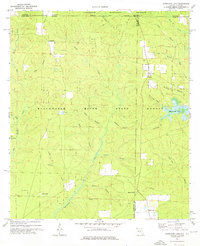
1973 Map of Hurricane Lake
USGS Topo · Published 1976About this map
Blackwater River State Forest and the Conecuh National Forest meet along the Florida-Alabama border in this 1973 survey. The landscape is defined by an intricate network of waterways draining toward the Gulf, including Big Juniper Creek and Sweetwater Creek. While the terrain is heavily forested, small pockets of human settlement like Belandville and Munson appear alongside several rural cultural landmarks. Genealogists may find interest in the Bullard Ch and Valley Grove Ch, as well as the Hobbs Cem located near the Santa Rosa and Okaloosa County line. The eastern edge of the map is dominated by the waters of Hurricane Lake, created as a recreational feature within the state forest system. Local industry is represented by several pipelines and a network of jeep trails used for timber management and fire access across the drainage basins of Bear Branch and Crane Branch.
Find a feature on this map
36 named features on this map. Tap any name to fly to it.
Don’t see what you’re looking for? This feature index may not catch every label — zoom into the map to look around manually.
Map Details
Editions of this 1973 Hurricane Lake Map
This is the sole edition of this map. No revisions or reprints were ever made.
Other maps of this area

1948 · Munson
USGS Topo · 1:62,500

1949 · Crestview
USGS Topo · 1:62,500

1950 · Munson
USGS Topo · 1:62,500

1951 · Crestview
USGS Topo · 1:62,500

1953 · Andalusia
USGS Topo · 1:250,000

1957 · Andalusia
USGS Topo · 1:250,000

1957 · Pensacola
USGS Topo · 1:250,000

1959 · Pensacola
USGS Topo · 1:250,000

1960 · Pensacola
USGS Topo · 1:250,000

1971 · Bradley
USGS Topo · 1:24,000