Loading...
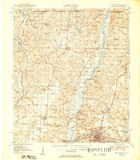
Loading map...1951 Map of Crestview
USGS Topo · Published 1951About this map
The confluence of the Yellow River and Shoal River southeast of Crestview anchors this mid-century portrait of Okaloosa County. The landscape is defined by the intersection of traditional river-bottom life and modernizing infrastructure, where the Louisville and Nashville Railroad and the Old Spanish Trail run parallel through the county seat. The map reveals a dense network of rural religious life, featuring numerous country sanctuaries such as Clear Springs Church, Pyron Spring Chapel, and Old Bethel Ch.
Find a feature on this map
113 named features on this map. Tap any name to fly to it.
Don’t see what you’re looking for? This feature index may not catch every label — zoom into the map to look around manually.
Map Details
Date Portrayed1951
Date Published1951
PublisherU.S. Geological Survey
Map TypeTopographic
Scale1:62,500
Physical Dimensions18.2 x 20.9 inches
Editions of this 1951 Crestview Map
2 editions found
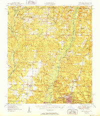
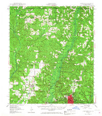
Historical Maps of Crestview Through Time
3 maps found

Featured Locations
Source Details
SourceU.S. Geological Survey
CopyrightPublic Domain