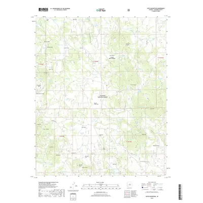
2018 Map of Hutch Mountain
USGS Topo · Published 2018About this map
Coyote Basin Ranch sits within the high-altitude forested landscape of the Coconino National Forest, surrounded by a complex system of livestock and water management features. The area is defined by numerous tanks and springs, such as J Railroad Tank and Railroad Spring, which support ranching activities across the volcanic terrain. Prominent landmarks like Hutch Mtn and Gash Mtn overlook a series of open meadows and parks, including Pratt Park, Bill Back Park, and Double Cabin Park. The Arizona National Scenic Trail traverses the eastern half of the map, threading between Coyote Basin and the slopes of Mahan Mtn. This late 2010s survey records a landscape where modern forest management, represented by Fire Rd 92A, meets a long-standing ranching legacy evident in the named tanks and mountain buttes.
Find a feature on this map
112 named features on this map. Tap any name to fly to it.
Don’t see what you’re looking for? This feature index may not catch every label — zoom into the map to look around manually.
Map Details
Editions of this 2018 Hutch Mountain Map
This is the sole edition of this map. No revisions or reprints were ever made.
Other maps of this area

1887 · Verde
USGS Topo · 1:250,000

1892 · Verde
USGS Topo · 1:250,000

1923 · Camp Verde
USGS Topo · 1:125,000

1932 · Camp Verde
USGS Topo · 1:125,000

1936 · Camp Verde
USGS Topo · 1:125,000

1954 · Holbrook
USGS Topo · 1:250,000

1957 · Holbrook
USGS Topo · 1:250,000

1958 · Holbrook
USGS Topo · 1:250,000

1960 · Holbrook
USGS Topo · 1:250,000
1965 · Hutch Mtn.
USGS Topo · 1:24,000