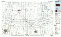
1985 Map of Hutchinson
USGS Topo · Published 1985About this map
Hutchinson and McPherson serve as the primary anchors of this mid-1980s central Kansas landscape, a region defined by its rigid section-line grid and a dense network of major railroads like the Atchison Topeka and Santa Fe and Missouri Pacific. The map captures a unique intersection of education and industry, showing an Oil Refinery near McPherson alongside several academic institutions, including Central College, Tabor College, and Bethel College. Water management is prominent in the eastern reaches where Marion Lake is surrounded by public use areas such as Durham Cove Public Use Area and Hillsboro Cove Public Use Area. The drainage of the Arkansas River and Little Arkansas River contrasts with the unusual geological features of Big Sinkhole and Little Sinkhole located near the town of Inman.
Find a feature on this map
119 named features on this map. Tap any name to fly to it.
Don’t see what you’re looking for? This feature index may not catch every label — zoom into the map to look around manually.
Map Details
Editions of this 1985 Hutchinson Map
2 editions found
Other maps of this area

1888 · Eldorado
USGS Topo · 1:125,000

1889 · Newton
USGS Topo · 1:125,000

1889 · Abilene
USGS Topo · 1:125,000

1889 · Parkerville
USGS Topo · 1:125,000

1889 · Cheney
USGS Topo · 1:125,000

1889 · Wichita
USGS Topo · 1:125,000

1891 · Hutchinson
USGS Topo · 1:125,000

1891 · Cheney
USGS Topo · 1:125,000

1892 · Salina
USGS Topo · 1:125,000

1892 · Kingman
USGS Topo · 1:125,000