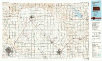
1985 Map of Hutchinson
USGS Topo · Published 1990About this map
The central Kansas agricultural and industrial corridor is mapped here in the mid-1980s, anchored by the hubs of Hutchinson, McPherson, and Newton. This region exhibits a dense grid of rural townships like New Gottland, Groveland, and Lone Tree, where the landscape is defined by the transition from prairie to intensive cultivation. Significant educational and industrial infrastructure is visible, including McPherson College and an Oil Refinery on the outskirts of McPherson, alongside Bethel College in Newton.
Find a feature on this map
136 named features on this map. Tap any name to fly to it.
Don’t see what you’re looking for? This feature index may not catch every label — zoom into the map to look around manually.
Map Details
Editions of this 1985 Hutchinson Map
2 editions found
Other maps of this area

1888 · Eldorado
USGS Topo · 1:125,000

1889 · Newton
USGS Topo · 1:125,000

1889 · Abilene
USGS Topo · 1:125,000

1889 · Parkerville
USGS Topo · 1:125,000

1889 · Cheney
USGS Topo · 1:125,000

1889 · Wichita
USGS Topo · 1:125,000

1891 · Hutchinson
USGS Topo · 1:125,000

1891 · Cheney
USGS Topo · 1:125,000

1892 · Salina
USGS Topo · 1:125,000

1892 · Kingman
USGS Topo · 1:125,000