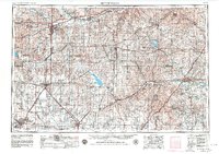
1955 Map of Hutchinson
USGS Topo · Published 1980About this map
The Flint Hills rise across the eastern portions of this central Kansas landscape, where the Neosho River and Cottonwood River drain toward the southeast. In the mid-1950s, the region was defined by a dense network of railroads including the Atchison Topeka and Santa Fe and the Union Pacific, supporting agricultural hubs like Abilene, McPherson, and Newton. To the north, the Osage Practice Bombing Range No. 3 reflects the era's military presence, while the St. Francis Boys Home outside Salina serves as a notable local landmark. The map details the early development of significant reservoirs, showing Kanopolis Lake and Council Grove Lake, which altered the natural flow of the Smoky Hill River and its tributaries. This survey captures the transition from a rail-dominated prairie economy to one increasingly integrated by the growing federal highway system, including U. S. 40 and U. S. 50.
Find a feature on this map
183 named features on this map. Tap any name to fly to it.
Don’t see what you’re looking for? This feature index may not catch every label — zoom into the map to look around manually.
Map Details
Editions of this 1955 Hutchinson Map
3 editions found

Other maps of this area

1885 · Eskridge
USGS Topo · 1:125,000

1885 · Burlington
USGS Topo · 1:125,000

1885 · Eureka
USGS Topo · 1:125,000

1886 · Fredonia
USGS Topo · 1:125,000

1886 · Junction City
USGS Topo · 1:125,000

1888 · Emporia
USGS Topo · 1:125,000

1888 · Eureka
USGS Topo · 1:125,000

1888 · Eldorado
USGS Topo · 1:125,000

1889 · Burlingame
USGS Topo · 1:125,000

1889 · Newton
USGS Topo · 1:125,000