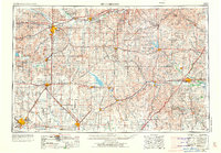
1955 Map of Hutchinson
USGS Topo · Published 1973About this map
The Flint Hills dominate the eastern landscape of this central Kansas region, where the prairie meets a dense network of river systems and mid-century infrastructure. Major population centers like Hutchinson, Salina, and Emporia are shown as they expanded in the late 1960s, connected by the burgeoning paths of Interstate 70 and Interstate 35W. This era marks a significant shift in the water landscape with the appearance of the Marion Reservoir, Council Grove Lake, and the John Redmond Res, which altered the historical flow of the Cottonwood River and Neosho River.
Find a feature on this map
164 named features on this map. Tap any name to fly to it.
Don’t see what you’re looking for? This feature index may not catch every label — zoom into the map to look around manually.
Map Details
Editions of this 1955 Hutchinson Map
3 editions found

Other maps of this area

1885 · Eskridge
USGS Topo · 1:125,000

1885 · Burlington
USGS Topo · 1:125,000

1885 · Eureka
USGS Topo · 1:125,000

1886 · Fredonia
USGS Topo · 1:125,000

1886 · Junction City
USGS Topo · 1:125,000

1888 · Emporia
USGS Topo · 1:125,000

1888 · Eureka
USGS Topo · 1:125,000

1888 · Eldorado
USGS Topo · 1:125,000

1889 · Burlingame
USGS Topo · 1:125,000

1889 · Newton
USGS Topo · 1:125,000