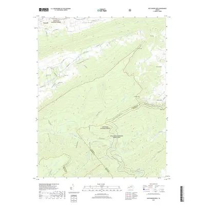
2019 Map of Hutchinson Rock
USGS Topo · Published 2019About this map
The ridge-and-valley topography of southwestern Virginia defines this area, where Jefferson National Forest covers much of the high ground. The Appalachian National Scenic Trail winds through the southern half of the map, crossing major landmarks like Walker Gap and following the rugged divide between Tazewell and Bland Counties. In the north, Thompson Valley and Clinch Valley host established rural settlements near Tazewell, with family heritage sites such as Thompson Cem, Buchanan Cem, and Crabtree Cem marking the historical footprint of local landowners. Significant hydrological features like Maiden Spring Cr and Beavers Brook Spring originate here, feeding the complex drainage system of the upper Clinch River watershed. The map provides clear detail of the unique circular landscape of Burkes Garden tucked against the eastern boundary, as well as prominent summits like Hutchinson Rock.
Find a feature on this map
53 named features on this map. Tap any name to fly to it.
Don’t see what you’re looking for? This feature index may not catch every label — zoom into the map to look around manually.
Map Details
Editions of this 2019 Hutchinson Rock Map
This is the sole edition of this map. No revisions or reprints were ever made.
Other maps of this area

1887 · Pocahontas
USGS Topo · 1:125,000

1889 · Wytheville
USGS Topo · 1:125,000

1891 · Tazewell
USGS Topo · 1:125,000

1891 · Pocahontas
USGS Topo · 1:125,000

1891 · Abingdon
USGS Topo · 1:125,000

1892 · Wytheville
USGS Topo · 1:125,000

1894 · Pocahontas
USGS Topo · 1:125,000

1894 · Abingdon
USGS Topo · 1:125,000

1895 · Tazewell
USGS Topo · 1:125,000

1895 · Pocahontas
USGS Topo · 1:125,000