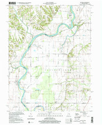
1998 Map of Hutton
USGS Topo · Published 2002About this map
The Wabash River snakes through the borderlands of Indiana and Illinois, defining a landscape of complex hydrology and agricultural history. On the eastern bank in Vigo County, the small settlement of Hutton sits near a network of cemeteries including Shattuck Cem and Watson Cem, which serve as quiet markers of the area's rural genealogy. The river's meandering course is punctuated by features like Aurora Bend and several backwater bodies such as Little Grassy Pond and Muskrat Pond, reflecting the shifting nature of the floodplain before modern stabilization.
Find a feature on this map
52 named features on this map. Tap any name to fly to it.
Don’t see what you’re looking for? This feature index may not catch every label — zoom into the map to look around manually.
Map Details
Editions of this 1998 Hutton Map
This is the sole edition of this map. No revisions or reprints were ever made.
Other maps of this area

1932 · Marshall
USGS Topo · 1:62,500

1937 · Marshall
USGS Topo · 1:62,500

1940 · Pimento
USGS Topo · 1:24,000

1941 · Terre Haute
USGS Topo · 1:24,000

1942 · Fairbanks
USGS Topo · 1:24,000

1942 · Shelburn
USGS Topo · 1:24,000

1942 · Hutton
USGS Topo · 1:24,000

1942 · Dennison
USGS Topo · 1:24,000

1948 · Terre Haute
USGS Topo · 1:24,000

1952 · Fairbanks
USGS Topo · 1:24,000