
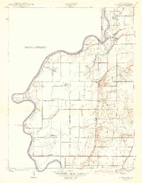
1942 Map of Hutton
USGS Topo · Published 1942About this map
The Wabash River carves a dramatic serpentine path along the Indiana and Illinois border, anchoring a landscape defined by its complex bottomland hydrology. Extensive bayous and sloughs, including Greenfield Bayou, Haworth Slough, and Jones Bayou, crisscross the fertile plains west of the settlement of Hutton. This 1930s-era topography reveals a rural society deeply tied to the river's movements, where the Darwin Ferry provided a vital link between the village of Darwin and the eastern bank.
Find a feature on this map
37 named features on this map. Tap any name to fly to it.
Don’t see what you’re looking for? This feature index may not catch every label — zoom into the map to look around manually.
Map Details
Editions of this 1942 Hutton Map
2 editions found
Other maps of this area

1932 · Marshall
USGS Topo · 1:62,500

1937 · Marshall
USGS Topo · 1:62,500

1940 · Pimento
USGS Topo · 1:24,000

1941 · Terre Haute
USGS Topo · 1:24,000

1942 · Fairbanks
USGS Topo · 1:24,000

1942 · Shelburn
USGS Topo · 1:24,000

1942 · Dennison
USGS Topo · 1:24,000

1948 · Terre Haute
USGS Topo · 1:24,000

1952 · Fairbanks
USGS Topo · 1:24,000

1952 · Shelburn
USGS Topo · 1:24,000