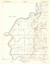
1942 Map of Hutton
USGS Topo · Published 1942About this map
The Wabash River forms a serpentine border between Indiana and Illinois in this 1939 survey, defining a landscape of bayous, ponds, and sloughs. Near Aurora Bend, the Darwin Ferry provided a critical river crossing connecting the small settlement of Darwin to the agricultural lands of Vigo County. The floodplain is marked by complex water features like Greenfield Bayou, Haworth Slough, and Blue Hole, illustrating the river's historical path and the resulting wetlands that dictated the placement of early infrastructure.
Find a feature on this map
39 named features on this map. Tap any name to fly to it.
Don’t see what you’re looking for? This feature index may not catch every label — zoom into the map to look around manually.
Map Details
Editions of this 1942 Hutton Map
2 editions found
Other maps of this area

1932 · Marshall
USGS Topo · 1:62,500

1937 · Marshall
USGS Topo · 1:62,500

1940 · Pimento
USGS Topo · 1:24,000

1941 · Terre Haute
USGS Topo · 1:24,000

1942 · Fairbanks
USGS Topo · 1:24,000

1942 · Shelburn
USGS Topo · 1:24,000

1942 · Hutton
USGS Topo · 1:24,000

1942 · Dennison
USGS Topo · 1:24,000

1948 · Terre Haute
USGS Topo · 1:24,000

1952 · Fairbanks
USGS Topo · 1:24,000