
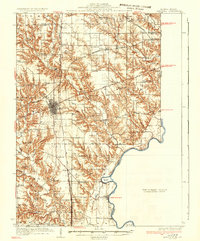
1937 Map of Marshall
USGS Topo · Published 1937About this map
The city of Marshall anchors this eastern Illinois landscape, serving as a hub for the Pennsylvania Railroad and State Highway No 1 during the mid-1930s. The terrain is defined by the winding Wabash River and its numerous tributaries, including Sugar Creek and Mill Creek, which have carved deep drainage patterns through the land. This survey reveals a remarkably dense network of rural infrastructure, from river crossings like Bohn Ferry and Waters Ford to an exceptional concentration of namesake country schools such as Rabbit Ridge Sch, Sassafras Sch, and Stringtown Sch. Local history and genealogy are deeply embedded in the many family and community cemeteries like Forsythe Cem and Ziegler Cem, while the riverfront near Darwin and Aurora Bend illustrates the region's enduring relationship with the water.
Find a feature on this map
77 named features on this map. Tap any name to fly to it.
Don’t see what you’re looking for? This feature index may not catch every label — zoom into the map to look around manually.
Map Details
Editions of this 1937 Marshall Map
2 editions found
Other maps of this area

1932 · Marshall
USGS Topo · 1:62,500

1936 · Casey
USGS Topo · 1:48,000

1940 · Pimento
USGS Topo · 1:24,000

1941 · Terre Haute
USGS Topo · 1:24,000

1942 · Fairbanks
USGS Topo · 1:24,000

1942 · Shelburn
USGS Topo · 1:24,000

1942 · Hutton
USGS Topo · 1:24,000

1942 · Dennison
USGS Topo · 1:24,000

1942 · Casey
USGS Topo · 1:62,500

1943 · Casey
USGS Topo · 1:62,500