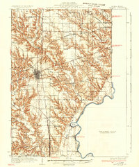
1937 Map of Marshall
USGS Topo · Published 1937About this map
The city of Marshall serves as the hub of this 1930s Clark County landscape, where the Pennsylvania and New York Central railroads intersect. The terrain transitions from the upland plains of Douglas and Elbridge down toward the winding Wabash River, which forms the eastern boundary with Indiana. This survey captures a network of rural life defined by its one-room schoolhouses, such as Rabbit Ridge Sch and Sassafras Sch, and small religious centers like Zion Ch and Craig Chapel. Along the river, landmarks like Aurora Bend and the Bohn Ferry indicate the importance of water crossings and river navigation. The early influence of aviation is also visible near Livingston, marked by the presence of an Airway Beacon along the route of U S Highway 40.
Find a feature on this map
70 named features on this map. Tap any name to fly to it.
Don’t see what you’re looking for? This feature index may not catch every label — zoom into the map to look around manually.
Map Details
Editions of this 1937 Marshall Map
2 editions found
Other maps of this area

1932 · Marshall
USGS Topo · 1:62,500

1936 · Casey
USGS Topo · 1:48,000

1937 · Marshall
USGS Topo · 1:62,500

1940 · Pimento
USGS Topo · 1:24,000

1941 · Terre Haute
USGS Topo · 1:24,000

1942 · Fairbanks
USGS Topo · 1:24,000

1942 · Shelburn
USGS Topo · 1:24,000

1942 · Hutton
USGS Topo · 1:24,000

1942 · Dennison
USGS Topo · 1:24,000

1942 · Casey
USGS Topo · 1:62,500