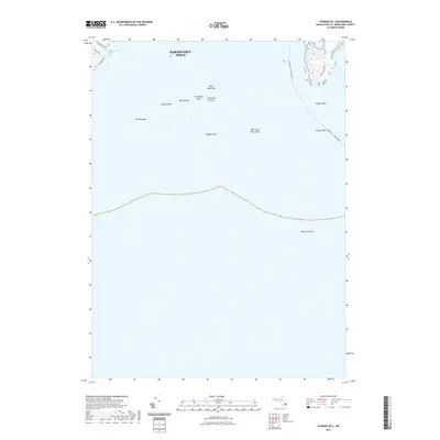
2021 Map of Hyannis OE S
USGS Topo · Published 2021About this map
Nantucket Sound dominates this maritime chart, where the coastal boundary of Barnstable Town meets the Atlantic waters of Cape Cod. The mapping focuses heavily on the underwater topography and hazards of the sound, documenting a series of significant nautical features including Collier Ledge, Hodges Rock, and the expansive Broken Ground. A clear transit corridor is marked by the Nantucket - Hyannis Ferry route, which threads through the shoals between Gazelle Rock and the mainland. In the northwestern corner, a small residential coastal pocket is detailed along the shoreline of Phinneys Bay and Crystal Lake. This area is defined by local thoroughfares such as Wianno Ave and E Bay Rd, providing a precise record of the developed waterfront and its proximity to the rocky seafloor that characterizes this stretch of the Massachusetts coast.
Find a feature on this map
18 named features on this map. Tap any name to fly to it.
Don’t see what you’re looking for? This feature index may not catch every label — zoom into the map to look around manually.
Map Details
Editions of this 2021 Hyannis OE S Map
This is the sole edition of this map. No revisions or reprints were ever made.
Other maps of this area

1887 · Muskeget
USGS Topo · 1:62,500

1887 · Yarmouth
USGS Topo · 1:62,500

1888 · Barnstable
USGS Topo · 1:62,500

1889 · Muskeget
USGS Topo · 1:62,500

1889 · Yarmouth
USGS Topo · 1:62,500

1893 · Muskeget
USGS Topo · 1:62,500

1893 · Yarmouth
USGS Topo · 1:62,500

1893 · Barnstable
USGS Topo · 1:62,500

1899 · Muskeget
USGS Topo · 1:62,500
1941 · Cotuit
USGS Topo · 1:31,680