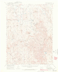
1956 Map of Hyannis Peak
USGS Topo · Published 1969About this map
The Rabbit Ears Range and the Continental Divide define this high-altitude landscape where the headwaters of the Colorado River basin begin to take shape. In the mid-1950s, the region was a network of high-country ranching operations and primitive trails, with family-named homesteads such as Van Valkenburg Ranch, Buffalo Ranch, and Haworth Ranch established along the drainage of Arapaho Creek and the Eastern Fork Muddy Creek.
Find a feature on this map
90 named features on this map. Tap any name to fly to it.
Don’t see what you’re looking for? This feature index may not catch every label — zoom into the map to look around manually.
Map Details
Editions of this 1956 Hyannis Peak Map
2 editions found

Other maps of this area

1911 · Hahns Peak
USGS Topo · 1:125,000

1913 · Hahns Peak
USGS Topo · 1:125,000

1954 · Craig
USGS Topo · 1:250,000

1955 · Teal Lake
USGS Topo · 1:24,000

1955 · Coalmont
USGS Topo · 1:24,000

1955 · Owl Ridge
USGS Topo · 1:24,000

1955 · Mac Farlane Reservoir
USGS Topo · 1:24,000

1955 · Mount Ethel
USGS Topo · 1:62,500

1955 · Walden
USGS Topo · 1:62,500

1956 · Rabbit Ears Peak
USGS Topo · 1:24,000