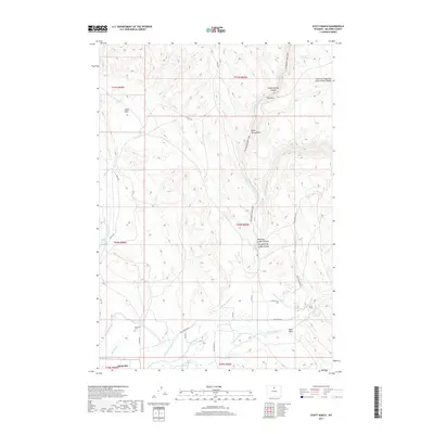
2017 Map of Hyatt Ranch
USGS Topo · Published 2017About this map
Hyattville sits at the southern edge of this Big Horn County landscape, where the waters of Paint Rock Cr meet an intricate network of irrigation systems like the Military Ditch and Go-Ahead Ditch. This 2017 survey reveals a terrain defined by its water management and grazing history, evidenced by the eponymous Hyatt Ranch and the expansive Medicine Lodge Big Game Winter Range to the northeast. The geography transitions from the low-lying Alkali Flats in the west toward the complex drainages of Medicine Lodge Canyon. For those tracing local history, the Hyattville Cem provides a point of genealogical reference, while natural landmarks such as The Arch and Sheep Springs Canyon illustrate the geological character of the canyonlands north of the settlement.
Find a feature on this map
36 named features on this map. Tap any name to fly to it.
Don’t see what you’re looking for? This feature index may not catch every label — zoom into the map to look around manually.
Map Details
Editions of this 2017 Hyatt Ranch Map
This is the sole edition of this map. No revisions or reprints were ever made.
Other maps of this area

1899 · Cloud peak
USGS Topo · 1:125,000

1901 · Cloud Peak
USGS Topo · 1:125,000

1955 · Sheridan
USGS Topo · 1:250,000

1958 · Sheridan
USGS Topo · 1:250,000

1960 · White Sulphur Spring
USGS Topo · 1:24,000

1960 · Flitner Reservoir
USGS Topo · 1:24,000

1960 · Spanish Point
USGS Topo · 1:24,000

1960 · Hyatt Ranch
USGS Topo · 1:24,000
1960 · Bush Butte
USGS Topo · 1:24,000

1962 · Sheridan
USGS Topo · 1:250,000