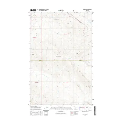
2014 Map of Hyde Creek
USGS Topo · Published 2014About this map
Lewis & Clark National Forest encompasses the high country of the Continental Divide in this northern Montana survey, where the border between Glacier and Pondera Counties bisects the terrain. The landscape is defined by massive formations like Lubec Ridge and Two Medicine Ridge, which overlook a complex network of alpine drainages including the S Fork Two Medicine River and the headwaters of Deep Creek. Significant peaks such as Mt Pablo and Mt Baldy rise above the valleys, while the secluded Dog Gun Lake sits at the terminus of Dog Gun Lake Road. The drainage patterns here are intricate, with numerous streams like Whiterock Creek and Red Poacher Creek carving through the slopes. This map provides a clear view of the high-altitude wilderness before the expansion of modern infrastructure, preserving the route of the Hughes Trail and the names of remote coulees such as Mettler Coulee.
Find a feature on this map
31 named features on this map. Tap any name to fly to it.
Don’t see what you’re looking for? This feature index may not catch every label — zoom into the map to look around manually.
Map Details
Editions of this 2014 Hyde Creek Map
This is the sole edition of this map. No revisions or reprints were ever made.
Other maps of this area

1913 · Marias Pass
USGS Topo · 1:125,000

1958 · Red Plume Mountain
USGS Topo · 1:24,000

1958 · Crescent Cliff
USGS Topo · 1:24,000

1960 · Cut Bank
USGS Topo · 1:250,000

1963 · Cut Bank
USGS Topo · 1:250,000

1964 · Cut Bank
USGS Topo · 1:250,000

1968 · Half Dome Crag
USGS Topo · 1:24,000
1968 · Morningstar Mountain
USGS Topo · 1:24,000
1968 · East Glacier Park
USGS Topo · 1:24,000
1968 · Squaw Mountain
USGS Topo · 1:24,000